Logistics
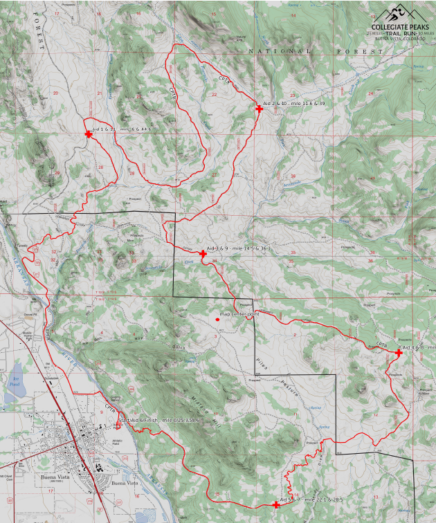
UPDATED COURSE MAP
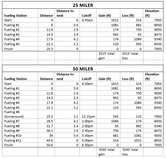
From 2004 thru 2015, the course was an accurate 25 miles in each direction. The Forest Service/Bureau of Land Management officials re-routed a portion. The course is now a 25.3 mile loop. Because of this change, runners who signup for 25 miles will actually run 25.3 miles and runners who signup for 50 miles will actually run 50.6 miles. The 50-milers have to finish the first loop by 12:15pm in order to be allowed to continue. Final cutoff time for ALL runners is 6:30pm. Should weather or other events necessitate changes to final aid station placements, intermediate aid-station cut-off times may be altered. Our goal is to provide information about any changes to runners as soon as possible and in as efficient a manner as possible. Of course, any known changes will be discussed at the pre-race meeting. 50-milers are allowed to “drop out” at the turnaround and become 25-mile runners.
COURSE DIRECTIONS
In addition to the topo map, gpx files and pdf, we strive to maintain what we consider to be a VERY WELL MARKED course – marked literally “by trail runners for trail runners.” All forms of directions are provided for either you over-achievers who want to come down before the race for “recon/training” runs and/or for those masochists among you who might want to revisit the scene of the crime sometime after the race!
ELEVATIONS
FUELING STATIONS
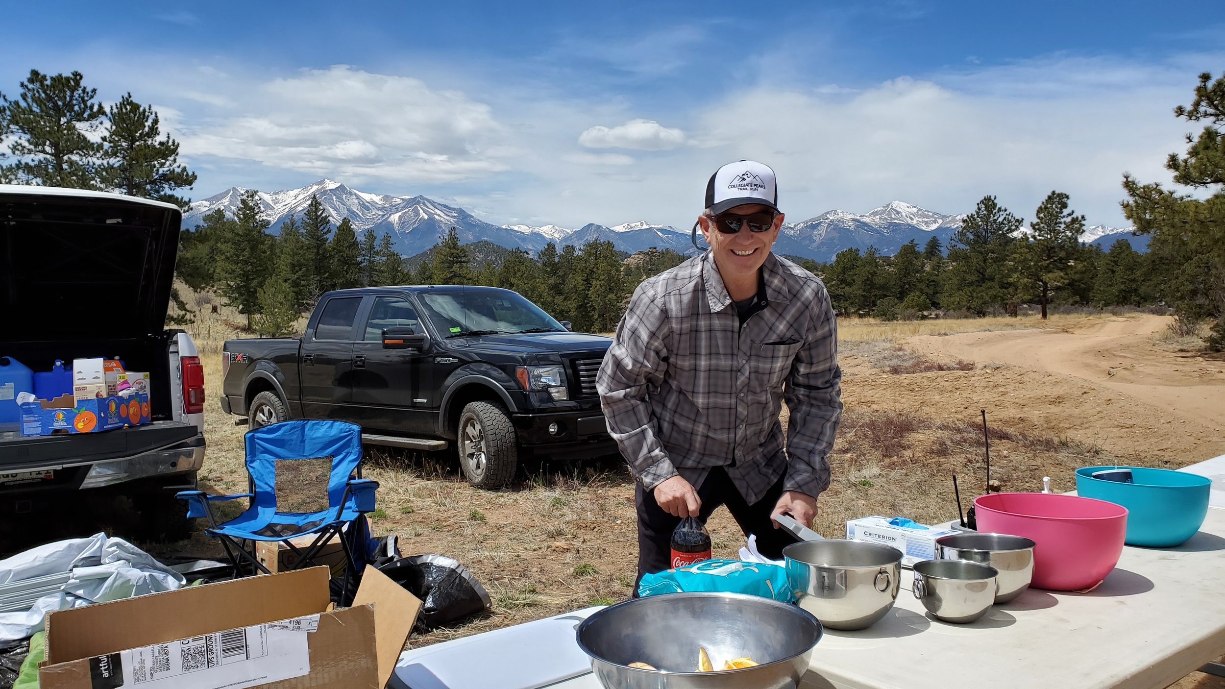
Each fueling station will offer, at a minimum, water, Tailwinds energy/hydration mix, and a variety of food (sweet, salty, etc.). All runners should carry extra water-carry capacity (bottles, bladders, etc.).
ALSO NOTE: CPTR fueling stations are CUP-FREE – SO, runners will need to carry their own drink receptacles/containers (water bottles, collapsible cups, etc.). As has been the case at races thru-out the U.S. and abroad, this decision was made recognizing changes in runners’ race practices and preferences as well as in recognition of environmental impacts.
Please respect the beautiful countryside that you will be passing through and LEAVE NO TRACE. Do not leave litter anywhere other than in clearly marked trash receptacles. Trash cans will be provided at each fueling station. Please discard all trash (wrappers, tissues, etc.) before continuing on the course. If you decide to continue onward taking food or drink with you, and/or are carrying your own supplies, please hold onto your trash until you reach the next fueling station.
Each fueling station is also supplied with minor first aid kits for runners (i.e., Vaseline, hydrogen peroxide, duct tape.). In case of injury or emergency, there is coordinated communication amongst fueling stations and centralized personnel at the Community Center. If you suffer an injury, head to the nearest fueling station. If that is not possible, please sit tight and ask a passing runner to alert race personnel as to your location and needs. PLEASE DO NOT EXIT THE COURSE UNDER ANY CIRCUMSTANCES WITHOUT ASSISTANCE, GUIDANCE, AND KNOWLEDGE OF A RACE OFFICIAL. 50-milers are tracked/monitored on their second loop from fuel station to fuel station and the course is swept in conjunction with each cutoff (See Cutoff Times in EVENT SCHEDULE). While we hope that all starters do finish, most of the course is fairly readily accessible, allowing for assistance off the course as needed.
ACCOMMODATIONS
All things are relative, yes, but for most folks as our town is 'charmingly small.' When looking for lodging in Buena Vista (“BV”), pretty much anywhere in town will be in close proximity to Race Central (Packet Pickup, Start / Finish, etc aka BV Community Center, 715 E. Main Street). Outside of town, of course, distances begin to increase and you’ll likely want to check our venue parking information….
Camping
Camping (in car or otherwise) is generally prohibited with town limits. Outside of town, camping is available on some public lands and / or from commercial providers.
A great starting point respective to public lands can be found at https://www.fs.usda.gov/recarea/psicc/recarea/?recid=21414
For private facilities, there are a number of campgrounds and RV parks in relatively close proximity to the Town of BV – accessible adjacent to the main roads coming into town (e.g. Hwy 24 including the unincorporated towns of Johnson’s Village and Nathrop just south of BV, Hwy 24 north of town, and County Rd 306 (leading west out of town towards Cottonwood Pass).
Hotels/Motels and Other Residential Rentals
Many options are available within and outside of town limits – in terms of convenience, distance, level of amenities, etc. We suggest simply checking the ‘standard’ info sources such as BV Chamber of Commerce, Google Maps, VRBO.com, AirBNB.com, etc.
Please do not hesitate to reach out to us with any specific lodging questions you may still have.
* All Lodging information is provided in good faith and obtained from publicly available sources at time of writing.


