

Distance and Time
From 2004 thru 2015, the course was an accurate 25 miles in each direction. The Forest Service/Bureau of Land Management officials re-routed a portion. The course is now a 25.3 mile loop. Because of this change, runners who signup for 25 miles will actually run 25.3 miles and runners who signup for 50 miles will actually run 50.6 miles. The 50-milers have to finish the first loop by 12:15pm in order to be allowed to continue. Final cutoff time for ALL runners is 6:30pm. Should weather or other events necessitate changes to final aid station placements, intermediate aid-station cut-off times may be altered. Our goal is to provide information about any changes to runners as soon as possible and in as efficient a manner as possible. Of course, any known changes will be discussed at the pre-race meeting. 50-milers are allowed to “drop out” at the turnaround and become 25-mile runners.
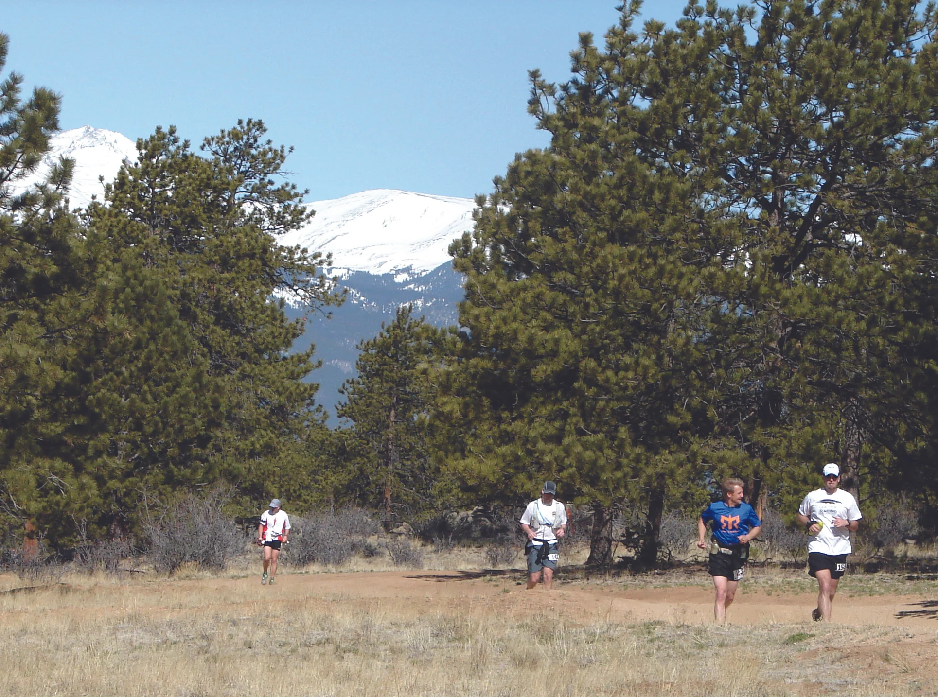
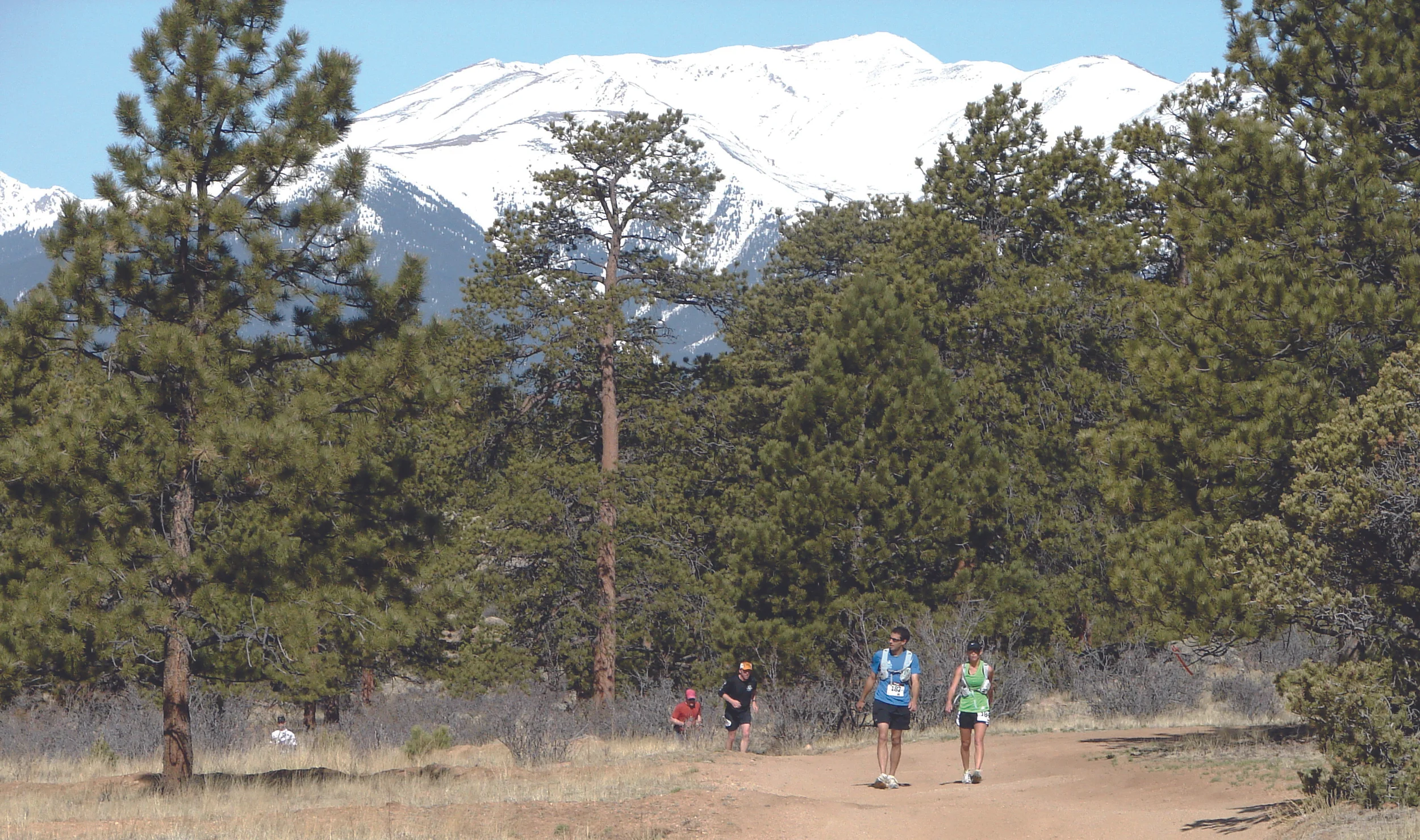
A great day for a run and spectacular views!
Course Markings
Our practice is to provide a course marked "by runners for runners". Generally, we use a combination of the following primary materials: flagging (usually orange), red wire flags, and flour. A few things to keep in mind. Flagging is the primary course marking. All turns will be CLEARLY marked. So, if you get to what looks like an intersection, do not make a turn unless it is CLEARLY marked to do so. Otherwise, proceed straight ahead. Turns are generally marked "on the inside" of the turn you're making (e.g., for right turns, most markings are on your right side and vice versa). The red wire flags (stuck into the ground) are often used for this "inside" marking. Flour will also be used "inside" but may also be on the outside and will normally be in the form of arrows.
While this gives you an overview of our general course marking practices, you should plan to attend the pre-race meeting for updates to these practices as well as to any possible changes or additions to course marking materials.
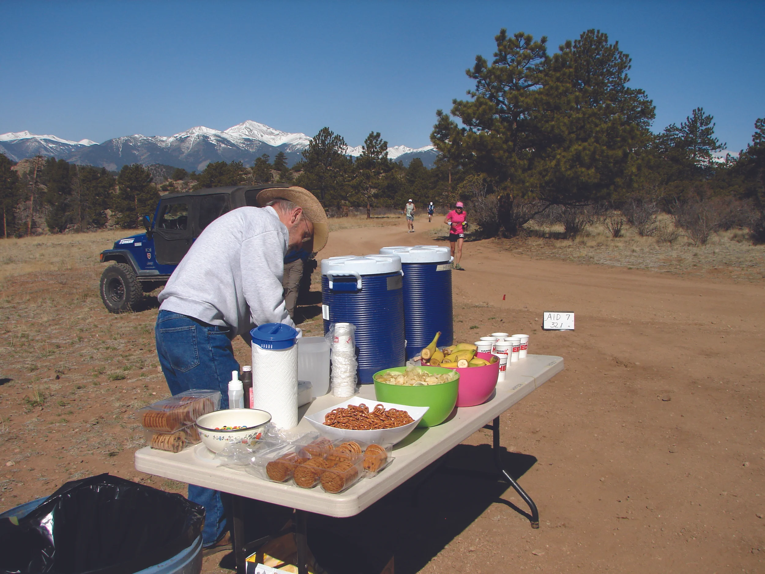
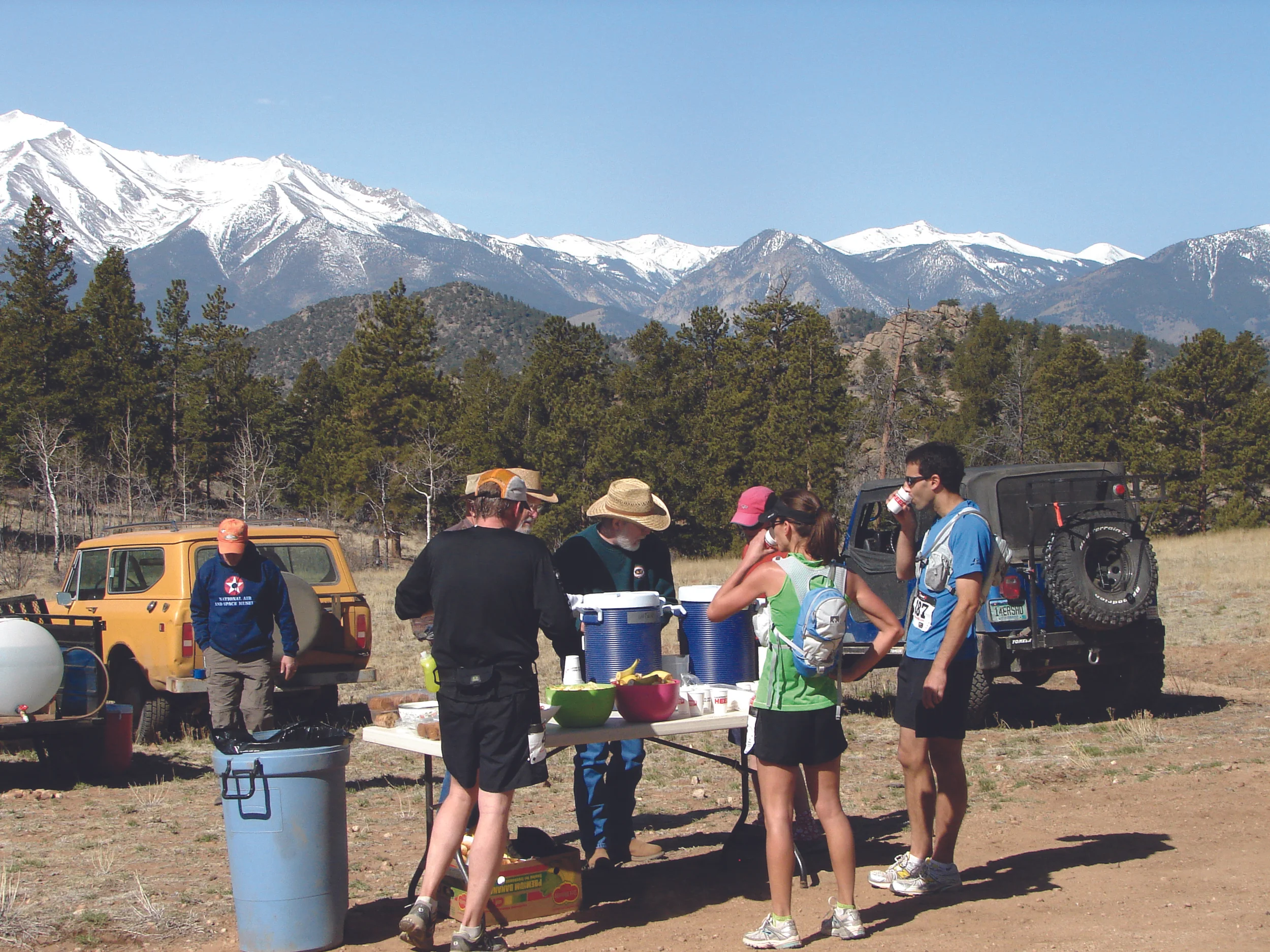
Aid Stations
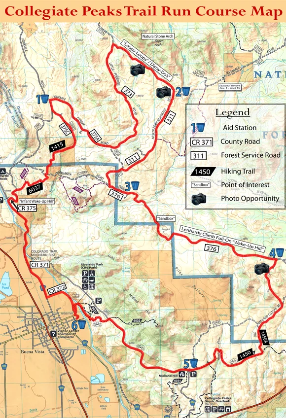
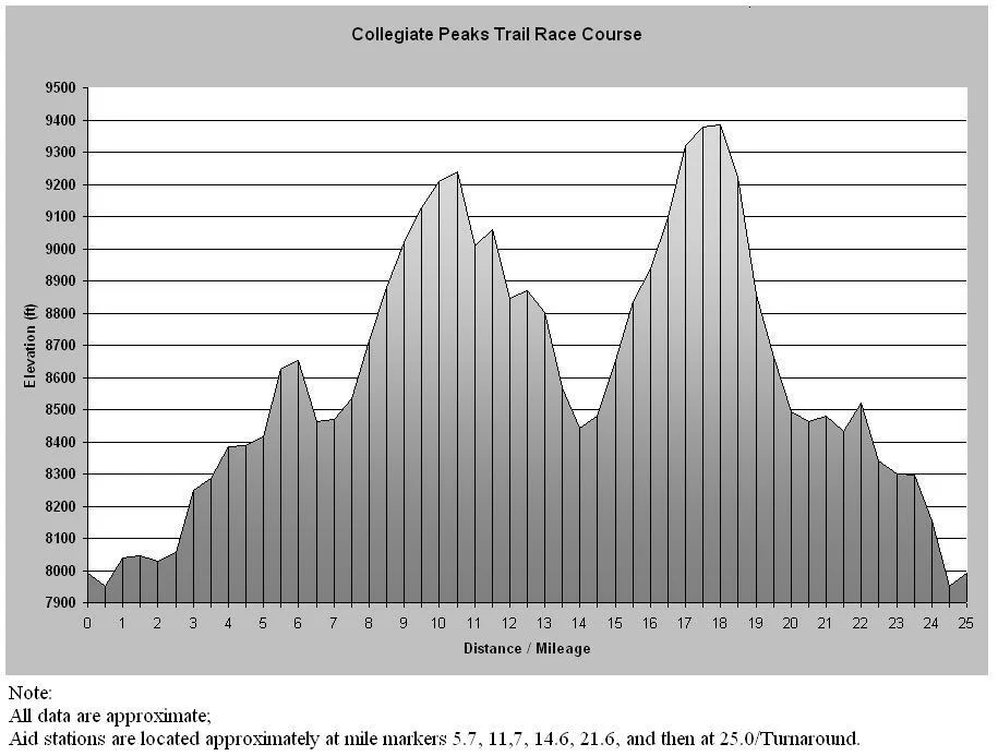
There are five aid stations on the course. They are located approximately at mile markers 5.7, 11.6, 14.4, 17.6, 22.1, and at the 25.3/Turnaround. The aid station at the 25.3/Turnaround point is specifically for the 50-milers. Note: Aid Station mile markers may change due to Forest Service/Bureau of Land Management course changes (see Race Course Distance and Time section).
Each aid station will offer, at a minimum, water, Gnarly energy/hydration mix, and a variety of food (sweet, salty, etc….). All runners should carry extra water-carry capacity (bottles, bladders, etc….).
PLEASE NOTE COVID Protocols: TBD - if change in circumstances occurs between the time of this posting and Race Day.
ALSO NOTE: CPTR aid stations are CUP-FREE – SO, runners will need to carry their own drink receptacles/containers (water bottles, collapsible cups, etc….). As has been the case at races thru-out the U.S. and abroad, this decision was made recognizing changes in runners’ race practices and preferences as well as in recognition of environmental impact implications.
Please respect the beautiful countryside that you will be passing through and do not leave litter anywhere other than in clearly marked trash receptacles. Trash cans will be provided at each aid station. Please discard all trash (wrappers, tissues, etc…) before continuing on the course. If you decide to continue onward taking food or drink with you, and/or are carrying your own supplies, please hold onto your trash until you reach the next aid station.
Each aid station is also supplied with minor first aid kits for runners (i.e., Vaseline, hydrogen peroxide, duct tape,...). In case of injury or emergency, there is coordinated communication amongst aid stations and centralized personnel at the Community Center. If you suffer an injury, head to the nearest aid station. If that is not possible, please sit tight and ask a passing runner to alert race personnel as to your location and needs. PLEASE DO NOT EXIT THE COURSE UNDER ANY CIRCUMSTANCES WITHOUT ASSISTANCE, GUIDANCE, AND KNOWLEDGE OF A RACE OFFICIAL. 50-milers are tracked/monitored on their second loop from aid station to aid station and the course is swept in conjunction with each cutoff (See Cutoff Times in RACE DETAILS). While we hope that all starters do finish, most of the course is fairly readily accessible, allowing for assistance off the course as needed.
Getting Things Ready
Taking a break

Water Crossings
There is one water crossing on the course at approximately mile 10”ish” and then again, for the 50 milers, at mile 40”ish”. Up until 2014, due to long term drought conditions, the stream had been dry for most years. However, depending on the weather, it can be fairly deep and fairly wide with the possibility of getting a bit wet. Any adverse conditions will be discussed at the Pre-Race Meeting.
Course Map
Course Elevation
Course Directions
In addition to the topo map, the following text directions may be helpful. Please note, these directions should NOT be considered as needed at all on Race Day. We strive to maintain what we consider to be a VERY WELL MARKED course – marked literally “by trail runners for trail runners.” These directions are provided for either you over-achievers who want to come down before the race for “recon/training” runs and/or for those masochists among you who might want to revisit the scene of the crime sometime after the race!
25-MILE LOOP (Clockwise)
Abbreviations:
CR = County Road (metal, typical Colorado road signage)
FSR = Forest Service Road (typical brown, plastic forest service free-standing signage
or, white and green signage attached to wooded posts)FST = Forest Service Trail (same as for FSR)
TCMM = Total course mile mark
Beginning from the Community Center, follow dirt/gravel road toward river. Road will turn NORTH as it leads down to the river. Continue following the road past the foot-bridge that leads across the river. DO NOT turn onto the foot bridge. From the foot-bridge, road continues up a very short rise where it begins to turn LT/WEST – At that point, you will see a foot-path leading NORTH along and above the river – follow this. At approx 1 mile total distance from Community Center, you will come to an intersection on the foot-path. Turn LT and you should see the beginning of a paved road approximately 100 yards out – head for that pavement.
This paved road is CR 372. Follow 372 approx 200 yards until it intersects (ends) at CR 371. Turn RT onto CR 371. From here, directions are as follows:
CR 371 approx 2 miles to CR 375. Turn RT. (If you reach tunnels, you just passed 375 – go back!)
CR 375 up hill approx ½ mile until road appears to have fully topped out (“plateaued”). Atthis point, road should take a hard LT turn. Continue straight off road into a very small natural parking area (space for 2-3 cars). You should almost immediately see sign for, and beginning of, FST 6037.
FST 6037 to FSR 376; Turn RT. Go about 50 yards and look for FST 1415 beginning on left side of the road.
FST 1415 to CR 375C.
CR 375C to CR 375 (approx TCMM 6). Turn RT. Go approx ¼ mile to FSR 375A.
FSR 375A to FSR 373 (At this point, 375A is ending/intersecting at 373. If you are simply running along, you should transition correctly onto 373 without any actual turn - without even realizing it. However, for those of you really who do see the signage, DO NOT turn right onto 373).
FSR 373 (or still “375A” for those of you who didn’t realize the transition) – follow several miles until intersecting/ending at FSR 311. Near the bottom of a hill in the trees, FSR373A will continue straight, while FSR 373 takes a right turn. Stay on FSR 373. Note, as you are heading towards the intersection with FSR 311, you will pass by a natural stone archway up in the rocks to left of the course somewhere around TCMM 10.8 to 11.2. The best view is at the top of the first very steep hill. TCMM at intersection with 311 is 11.7. Turn RT onto FSR 311.
FSR 311 to FSR 376; turn LT.
FSR 376 to FSR 376A (This interesting section is approx 3.5 miles in length beginning with a trek through a usually very sandy area and concluding with the famous/infamous two-mile climb up ‘Lenhardy Hill’ (all runnable, but for most, a bit of a grind). Top of hill is race elevation high point of about 9400ft and on race day, a welcomed aid station! (approx TCMM17.9). Turn RT.
FSR 376A DOWNHILL, then a rolling downhill, to the intersection with Sausage Links Trail, heading towards the Midland Trail.
Follow Sausage Links (using the “easy route”options) to its end at the intersection with the Midland Trail, about 1.9 miles. Turn right on the Midland Trail (towards the mountains).
1450/Midland Trail approximately 0.2 miles to CR 304 and Aid Station 5 (approx TCMM 22.1). Continue straight forward onto CR from trail – DO NOT turn left on 304.
CR 304 approx 2 miles – where you will see trails leading off the road - both to the right and to the left. To the right is FST 6032 – DO NOT take this trail. Instead, take the South trail on the left marked with Midland Trail circle on post. This is a steep 0.9 mile descent down to the river and to the foot-bridge that you passed when starting out some 3 hours earlier.
Cross bridge, turn LT, and proceed back up to the Community Center for a well earned reward of your choosing!!!!!!!!